NOAA Fisheries Groundfish Trawl Surveys
The IPHC partners with the National Oceanic and Atmospheric Administration to collect Pacific halibut data during their groundfish bottom trawl surveys conducted in the summer months. The Bering Sea is surveyed annually and both the Gulf of Alaska and Aleutian Islands are surveyed biennially. Summaries of Pacific halibut data collection and results on the trawl surveys are provided here, and within each summary are links to additional information and data.
Bering Sea NOAA-Fisheries Bottom Trawl Survey in 2018
Posted January 2019. This report was prepared in cooperation with NOAA Fisheries/Alaska Fisheries Science Center
OVERVIEW
The National Oceanic and Atmospheric Administration (NOAA) – Fisheries has conducted annual bottom trawl surveys on the eastern Bering Sea (EBS) continental shelf since 1979. In cooperation with NOAA-Fisheries, the International Pacific Halibut Commission (IPHC) has deployed a staff member (sea sampler) on the NOAA-Fisheries survey every year since 1998 to collect Pacific halibut (Hippoglossus stenolepis) samples. When participating in the NOAA trawl survey, the IPHC sea sampler becomes part of a team of scientists that are tasked with carrying out sampling objectives related to stock assessment and year-class strength estimation for numerous groundfish and crab species. The IPHC sea sampler serves as a Pacific halibut specialist, and also assists NOAA biologists in achieving their survey goals.
The IPHC operates a coastwide fishery-independent setline survey as the primary source of data for the Pacific halibut stock assessment (IPHC 2019). However, Pacific halibut occupy a vast area of the Bering Sea shelf for which the IPHC lacks the financial resources to sample in its entirety on a regular basis. Therefore, in most years, the NOAA trawl survey is the only measure of abundance for much of this area.
Survey trawl gear has different size selectivity than setline gear, making it necessary to apply a selectivity curve to include these data directly in the Pacific halibut stock assessment that is generated by the IPHC. Pacific halibut are vulnerable to the trawl from about 20-100 cm fork length (FL) (Clark et al. 1997), but a substantial portion of the commercial-sized population (O32 or > 81.3 cm FL) exceeds 100 cm. In 2006, and again in 2015, the IPHC added shelf stations to its fishery-independent setline survey in the Bering Sea region in order to compare information from these stations with data collected on the NOAA trawl survey. After the study in 2006, the IPHC concluded that the trawl survey, along with periodic IPHC fishery-independent setline survey calibrations, provided an adequate accounting of Pacific halibut biomass on the EBS shelf (Clark and Hare 2007) and is a useful tool for constructing a population-density index for the IPHC stock assessment (Webster 2014). The 2015 calibration confirmed this earlier finding. In addition to its use as a stock assessment tool, trawl survey information is useful as a forecasting tool for cohorts approaching recruitment into the directed commercial fishery.
In 2018, there was also a “rapid-response” trawl survey that extended into the northern Bering Sea (NBS). The emergency trawl survey was prompted by unusually warm bottom temperatures on the EBS shelf and concerns that many fish populations had shifted north outside of the regular trawl survey area. The rapid response NBS trawl survey covered a similar but smaller area (158,286 km2) than the earlier standard NBS surveys in 2010 and 2017 (200,207 km2), and it utilized a 30×30 nautical mile grid, rather than a 20×20 nautical mile sampling grid. This resulted in only 49 stations sampled compared to the standard 144 stations (Fig. 1).
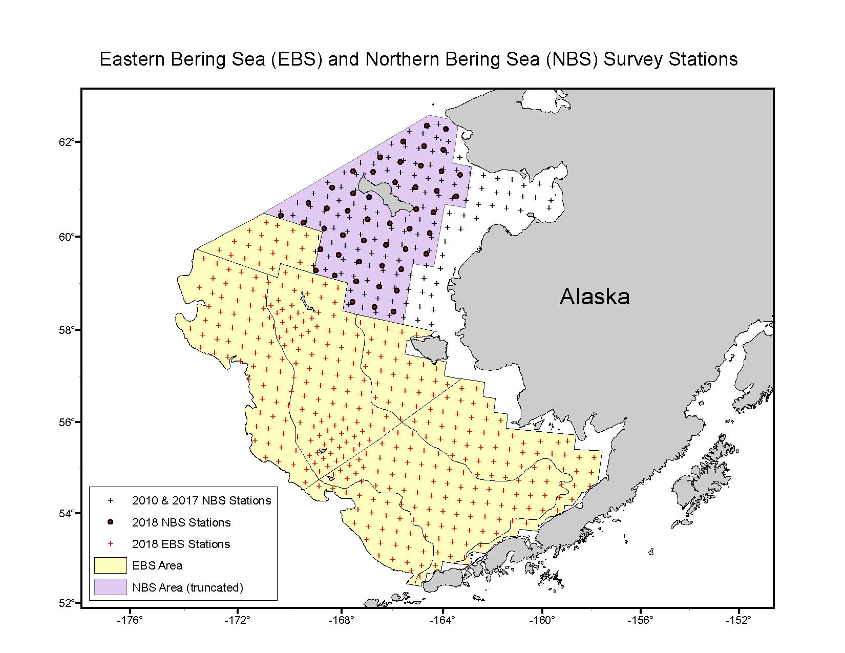 Figure 1. Sampling station design for the 2018 NOAA Bering Sea bottom trawl survey. Note that the grid north of the yellow area denotes the northern Bering Sea (NBS) extension. Black dots are stations sampled in the 2018 “rapid-response” NBS trawl survey and black plus signs are stations sampled in the 2010 and 2017 standard NBS trawl surveys.
SAMPLING DURING THE 2018 TRAWL SURVEY
For the first three of four trips, the IPHC sea sampler was aboard the F/V Vesteraalen, one of two vessels chartered by NOAA to complete the EBS trawl survey. During the final trip which included the northern extension, the IPHC sea sampler was aboard the F/V Alaska Knight.
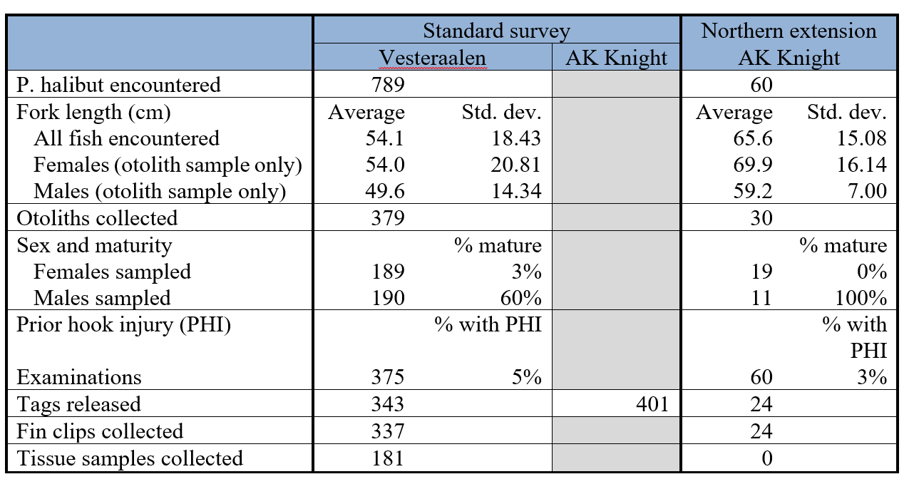
Pacific halibut were measured on all standard trawl survey tows aboard both vessels. Pacific halibut from tows aboard the vessel with an IPHC sea sampler onboard were assigned randomly into one of two groups: one for biological sampling, and one for wire tagging; with the goal of assigning 50% of the fish to each group. Fish in the tagging sample that were > 81 cm fork length, were released as soon as possible without a tag. Fish < 82 cm fork length were kept briefly in a live tank while sorting was taking place, and then assessed for condition using NOAA observer criteria and assigned to one of three condition categories (Excellent, Poor, Dead). Those fish with an assessment of Excellent and Poor were considered to have a high to moderate chance of survival and were outfitted with a wire tag through the operculum and released. Those fish assessed in the Dead category were measured and discarded. A fin clip was collected from each tagged fish for genetic analysis. For a full description of the tagging project, see the IPHC webpages on tagging.
Fish in the biological sample group were assessed for sex, maturity, and prior hooking injuries (PHI), and the otolith was removed for aging. An additional subsample was selected for the extraction of muscle samples as part of a study investigating growth patterns and for fin clips which will be used for a genetics study. Northern extension stations were treated the same as standard stations for sampling. Pacific halibut caught in tows at corner crab stations, and during duplicate tows, were excluded from the regular sample.
Pacific halibut from the vessel not staffed with an IPHC sea sampler were measured for fork length and randomly divided into two groups: tagging and no sample. Tagging criteria was the same as for the vessel with an IPHC sea sampler. Those fish in the no sample group were released.
RESULTS
ABUNDANCE AND BIOMASS ESTIMATES
In 2018, total Pacific halibut abundance in the EBS as estimated using catch data collected during the trawl survey was 50.5 million fish, a small decrease from the 53 million fish estimated in 2017, and a continuation of the decreasing trend started in 2006. Total biomass was estimated at just under 278 million pounds, which was only a slight decrease from the 279 million pounds estimated in 2017 (Fig. 2).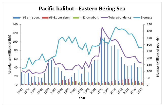
Figure 2. Pacific halibut abundance (millions of fish) and biomass (millions of pounds) in the eastern Bering Sea as estimated using data collected during the NOAA Bering Sea groundfish trawl survey for the years 1982-2018.
In order to make the abundance and biomass estimates comparable between the 2018 rapid response northern Bering Sea (NBS) survey and the 2010 and 2017 standard NBS trawl surveys, estimates for 2010 and 2017 excluded nearshore stations where no sampling was conducted in 2018. Comparing three years of survey data for the sampling area of the NBS, total Pacific halibut abundance and biomass estimates indicated a modest increase over the 2017 trawl survey (Fig. 3). The average fork length in the north was 65.6 cm, substantially larger than the 54.1 cm average fork length observed during the standard EBS trawl survey. Both the 2010 and 2017 northern extensions displayed similar size variations.
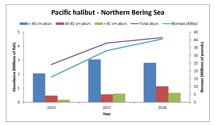
Figure 3. Pacific halibut abundance (millions of fish) and biomass (millions of pounds) in the northern Bering Sea (NBS) as estimated comparing the same areas sampled during the NOAA rapid response NBS trawl survey in 2018 with the standard NBS trawl surveys conducted in 2010 and 2017.
ADDITIONAL INFORMATION
- Interactive trawl survey data maps are available on the NOAA survey maps page.
- Full summary reports are prepared by NOAA/RACE for each trawl survey, usually within one year of completion of the trawl survey.
- NMFS protocols for groundfish bottom trawl surveys (Stauffer 2004).
REFERENCES
Clark W G and Hare S H. 2007. Assessment of the Pacific halibut stock at the end of 2006. IPHC Report of Assessment and Research Activities 2006: 97-128.
Clark W G, St-Pierre G, and Brown E S. 1997. Estimates of [Pacific] halibut abundance from NMFS trawl surveys. Int. Pac. Halibut Comm. Tech. Rep. 37.
IPHC (Erikson L., Soderlund E., and Geernaert T.). 2018. Fishery-independent setline survey (FISS) design and implementation in 2018, including current and future expansions. IPHC-2019-AM095-06.
Stauffer G. (compiler). 2004. NOAA Protocols for groundfish bottom trawl surveys of the nation’s fishery resources. NOAA technical memorandum NMFS-F/SP0-65.
IPHC participation on the NOAA Aleutian Islands groundfish bottom trawl survey
Posted June 2021. This report was prepared in cooperation with NOAA Fisheries/Alaska Fisheries Science Center.
OVERVIEW
The National Oceanic and Atmospheric Administration (NOAA) has conducted standardized bottom trawl surveys in the Aleutian Islands since 1984. In cooperation with NOAA, a field biologist from the International Pacific Halibut Commission (IPHC) was deployed on this survey in 1997 and 2000, and from 2012 to 2018 to collect information on Pacific halibut (Hippoglossus stenolepis).
Trawl survey gear can capture fish as small as 20 cm fork length which is smaller than fish caught during the IPHC fishery-independent setline survey (IPHC, 2020) or commercial fishery. These data are then used as an additional data source and verification tool for stock analysis and cohort forecasting.
The NOAA groundfish surveys are conducted in the summer months. Prior to 2000 the Aleutian Islands surveys were conducted every three years, and have taken place biennially since then. The exception was in 2008 when budget constraints mandated the cancellation of the survey and 2020 when the COVID-19 pandemic caused surveys to be cancelled. The survey typically covers the archipelago from Unimak Pass (165° W longitude) in the east to Stalemate Bank (170°E longitude) in the west. Depths range from inshore to about 500 m. The survey design is a stratified random sampling scheme (Stauffer 2004; Clark et al. 1997) consisting of 420 stations selected randomly from a combination of successful tows completed during previous surveys and sites not previously trawled. Beginning with the 1997 survey, a 15-minute tow at a speed of 3 nmi/hr has been attempted at each designated station with an average distance fished of approximately 1.5 km. Prior to that year, a 30-minute tow conducted at the same speed was attempted at each station.
IPHC SAMPLING
When participating in the NOAA trawl survey, the IPHC Secretariat staff member becomes part of a team of scientists that are tasked with gathering data for monitoring trends in distribution, abundance, and biological condition of various groundfish stocks in the northeast Pacific Ocean. The IPHC Secretariat staff member serves aboard one vessel as a Pacific halibut specialist, and also assists NOAA biologists in achieving their survey goals.
The NOAA groundfish bottom trawl survey in the Aleutian Islands is conducted with two vessels, each staffed with six scientists. The vessels fish in tandem throughout the range of the survey to obtain a representative sample of the area. They begin in the east and progress to the west. All Pacific halibut caught during the surveys are measured regardless of whether there are additional data collected. On the IPHC-staffed vessel, the Pacific halibut are additionally sampled for otoliths (earbones for aging), sex, maturity, and external examination for prior hooking injuries. In any given year, there may also be special projects such as tissue sampling or weights taken.
In 2016, the tagging project implemented by IPHC in 2015 was expanded to the Aleutian Islands bottom trawl survey. This tagging effort dictates that 50% of the sample be tagged and released if deemed viable based on criteria used by fishery observers and if they are U32 fish ( <82 cm fork length). The remaining 50% are sampled for otoliths as described above. In 2016, the data collection for tagged fish was expanded to include a fin clip which is used to determine genetic sex.
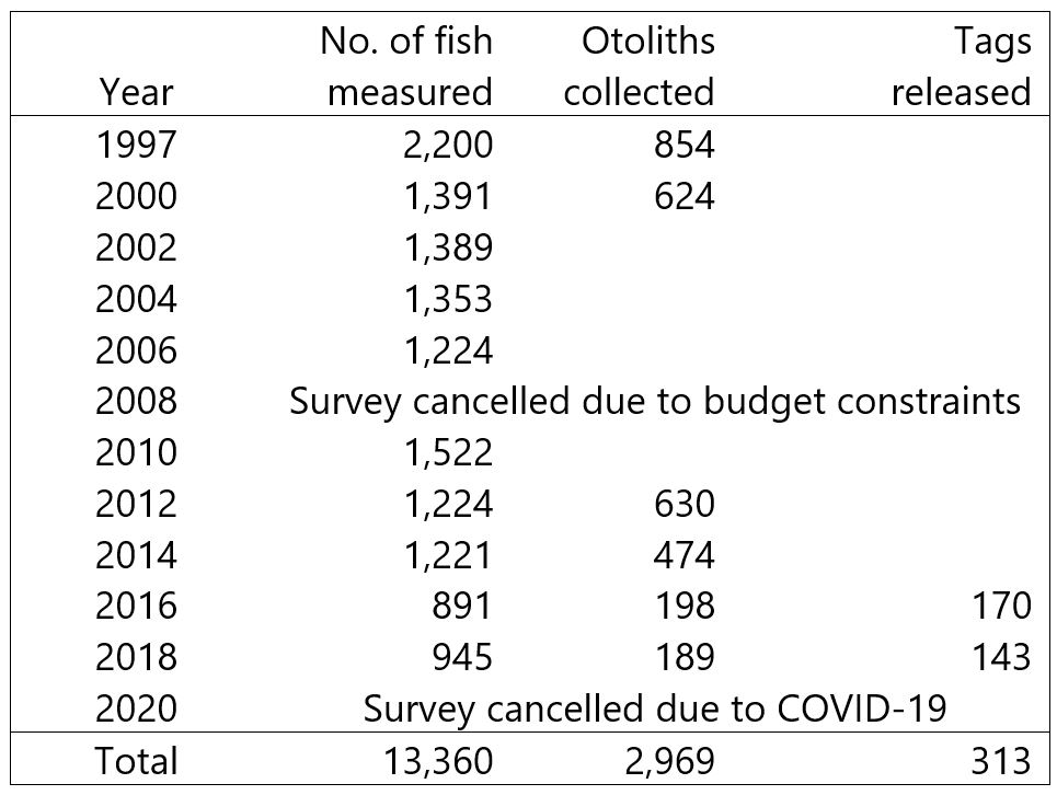
Since 1997, a total of 2,969 Pacific halibut otoliths have been collected and 313 fish have been tagged and released during this survey through 2020 (Table 1).
Table 1. Summary of Pacific halibut caught and sampled aboard the NOAA Aleutian Islands groundfish bottom trawl survey since the IPHC began participating in 1997.
ABUNDANCE AND BIOMASS ESTIMATES
In 2018, the relative abundance of Pacific halibut as estimated from the Aleutian Islands Bottom Trawl Survey was 6.7 million fish, a small decrease from the 7.0 million fish estimated in 2016. Abundance has decreased slightly since the mid-2000s, but in recent years, survey to survey variability appears to be relatively minor. Total biomass was estimated at 63 million pounds in 2018, which was essentially unchanged from 2016 (Fig. 1).
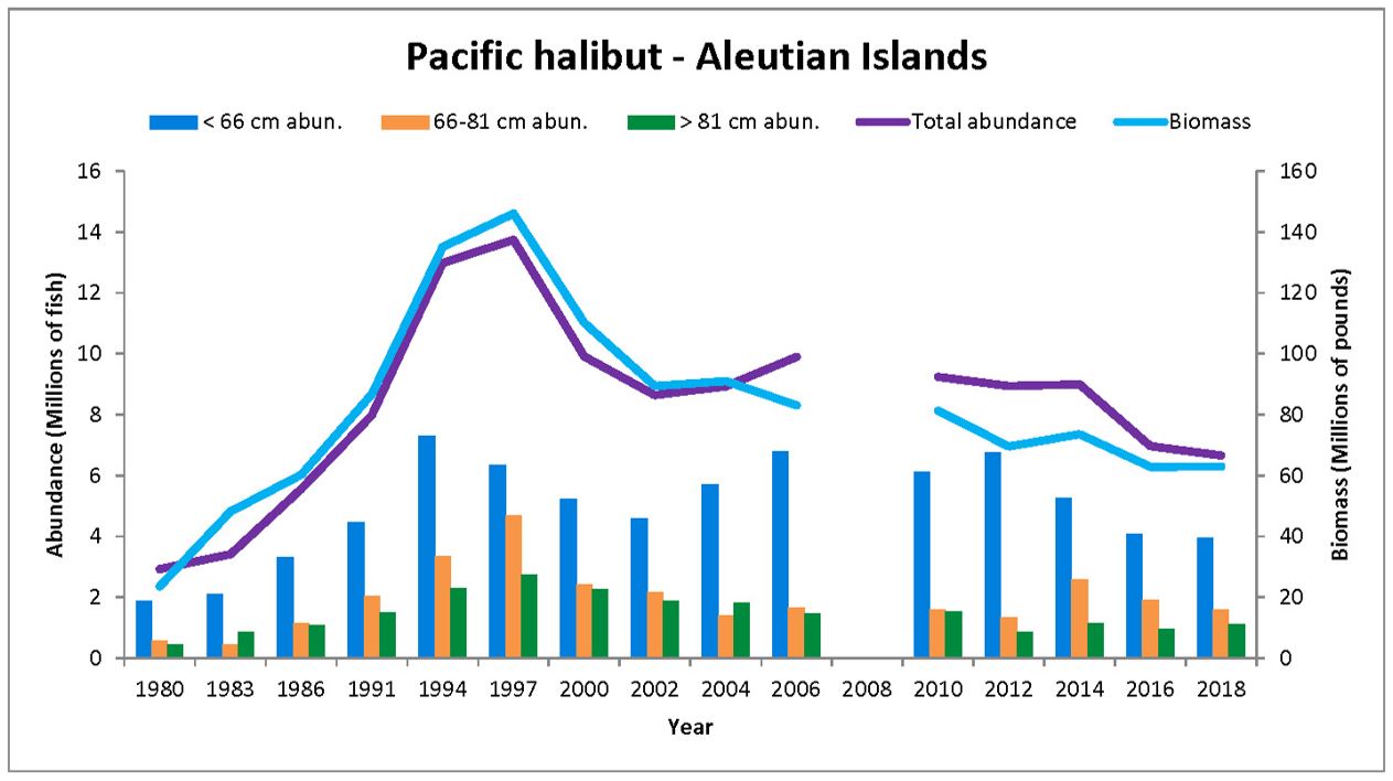
Figure 1. Pacific halibut abundance (millions of fish) and biomass (millions of pounds) in the Aleutian Islands as estimated using data collected during the NOAA Aleutian Islands groundfish bottom trawl survey for the years 1980-2018. Note that there was no survey in 2008 or 2020.
ADDITIONAL INFORMATION
- Interactive survey data maps are available on the NOAA survey maps page.
- Summary reports are prepared by NOAA/NMFS/RACE for each survey, usually within one year of completion of the survey.
- Protocols for NOAA groundfish bottom trawl surveys (Stauffer 2004).
REFERENCES
Clark, WG, St-Pierre, G, and Brown, ES (1997) Estimates of halibut abundance from NMFS trawl surveys. Int. Pac. Halibut Comm. Tech. Rep. 37.
IPHC (2020) IPHC Fishery-Independent Setline Survey (FISS) design and implementation in 2020. Paper: International Pacific Halibut Commission paper: IPHC-2021-AM097-06
Stauffer, G. (compiler) (2004) NOAA Protocols for groundfish bottom trawl surveys of the nation’s fishery resources. NOAA technical memorandum NMFS-F/SP0-65.
IPHC participation on the NOAA Gulf of Alaska groundfish bottom trawl survey
Posted June 2021. This report was prepared in cooperation with NOAA Fisheries/Alaska Fisheries Science Center
OVERVIEW
The National Oceanic and Atmospheric Administration (NOAA) has conducted standardized bottom trawl surveys in the Gulf of Alaska since 1984. In cooperation with NOAA, a Secretariat staff member from the International Pacific Halibut Commission (IPHC) was deployed on this survey from 1996-2019 to collect information on Pacific halibut (Hippoglossus stenolepis). Trawl survey gear can capture fish as small as 20 cm fork length which is smaller than fish caught during the IPHC fishery-independent setline survey (IPHC, 2020) or commercial fishery. These data are then used as an additional data source and verification tool for stock analysis and cohort forecasting.
The NOAA Gulf of Alaska groundfish surveys are conducted in the summer months. Prior to 1999 the Gulf of Alaska surveys were conducted every three years, and biennially thereafter. The survey begins in the west and typically covers the range from the Islands of Four Mountains (170° W longitude x 53° 30’ N latitude) in the west to Dixon Entrance (132° W longitude x 54° N latitude) in the east. The exception was in 2001 when budget and personnel constraints caused the survey to include a smaller area from the Islands of Four Mountains to the entrance of Prince William Sound in the central Gulf of Alaska. The 1993, 1996, and 2001 surveys placed stations at depths ranging between approximately 20 and 500 m. The 1999 and later surveys were extended into deeper waters of the GOA continental slope, to as deep as 1000 m, subject to budget and time constraints. The survey area is divided into 59 strata based on depth, major geographic features, and International North Pacific Fisheries Commission statistical areas (map can be found in Barnes et al. 2018), and employs a stratified random sampling scheme (Stauffer 2004; Clark et al. 1997). Beginning with the 1996 survey, a 15-minute tow at a speed of 3 nmi/hr was attempted at each designated station. Prior to that year, a 30-minute tow conducted at the same speed was attempted at each station.
IPHC SAMPLING
When participating in the NOAA trawl survey, the IPHC Secretariat staff member becomes part of a team of scientists that are tasked with gathering data for monitoring trends in distribution, abundance, and biological condition of various groundfish stocks in the northeast Pacific Ocean. The IPHC biologist serves aboard one vessel as a Pacific halibut specialist, and also assists NOAA biologists in achieving their survey goals.
The NOAA groundfish trawl survey in the Gulf of Alaska generally includes two to three vessels, each staffed with six scientists. Most stations are randomized among strata and vessel. All Pacific halibut caught during the surveys are measured regardless of whether there are additional data collected. On the IPHC-staffed vessel, the Pacific halibut are additionally sampled for otoliths (earbones for aging), sex, maturity, and external examination for prior hooking injuries. In any given year, there may also be special projects such as tissue sampling or weights taken.
In 2015, the IPHC implemented a wire tagging project whereby 50% of the sample was tagged and released if deemed viable based on criteria used by fishery observers, and the remaining 50% were sampled for otoliths as described above. In 2016, this project was modified to include the same 50% split, but tagging applied only to U32 Pacific halibut (< 82-cm fork length). Additionally in 2016, the data collection for tagged fish was expanded to include a fin clip which is used to determine genetic sex.
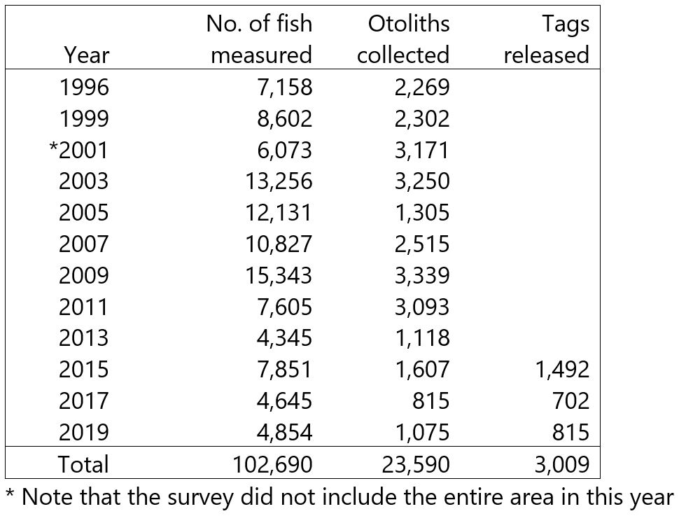
Since 1996, a total of 23,590 Pacific halibut otoliths have been collected and 3,009 fish have been tagged and released during this survey through 2019 (Table 1).
Table 1. Summary of Pacific halibut caught and sampled aboard the NOAA Gulf of Alaska groundfish trawl survey since the IPHC began participating regularly in 1996.
ABUNDANCE AND BIOMASS ESTIMATES
In 2019, the relative abundance of Pacific halibut as estimated from the Gulf of Alaska Bottom Trawl Survey was 122.9 million fish, an increase from the 113.8 million fish estimated in 2017. Estimated abundance and biomass in the 2010s was lower than the levels seen in the 2000s, but appears to have remained relatively constant over time (Fig. 1).
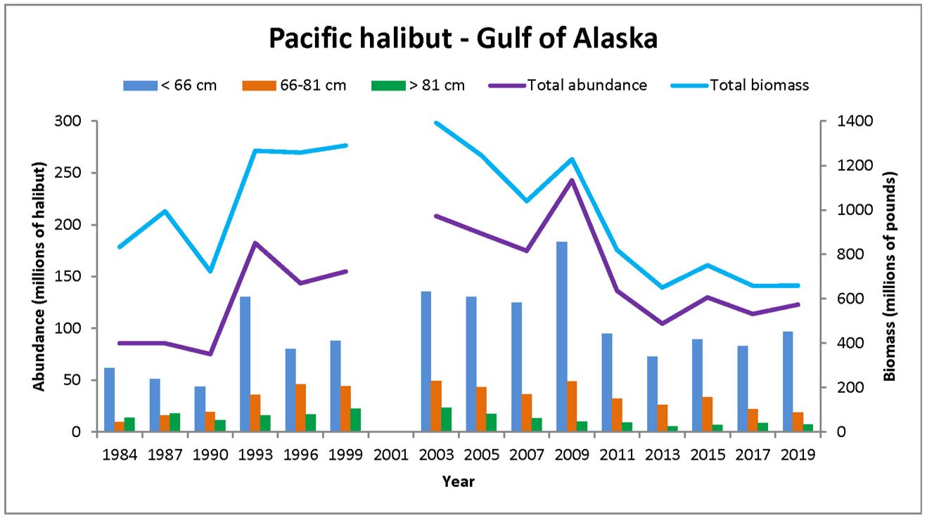
Figure 1. Pacific halibut abundance (millions of fish) and biomass (millions of pounds) in the Gulf of Alaska as estimated using data collected during the NOAA Gulf of Alaska groundfish bottom trawl survey for the years 1984-2019. Note that 2001 was a spatially truncated survey and is not included in this figure.
ADDITIONAL INFORMATION
- Interactive survey data maps are available on the NOAA survey maps page.
- Summary reports are prepared by NOAA/NMFS/RACE for each survey, usually within one year of completion of the survey.
- Protocols for NOAA groundfish bottom trawl surveys (Stauffer 2004).
REFERENCES
Barnes, CL, Beaudreau, AH, Hunsicker, ME, Ciannelli, L (2018) Assessing the potential for competition between Pacific halibut (Hippoglossus stenolepis) and Arrowtooth founder (Atheresthes stomias) in the Gulf of Alaska. PLOS ONE. https://doi.org/10.1371/journal.pone.0209402
Clark, WG, St-Pierre, G, and Brown, ES (1997) Estimates of halibut abundance from NMFS trawl surveys. Int. Pac. Halibut Comm. Tech. Rep. 37.
IPHC (2020) IPHC Fishery-Independent Setline Survey (FISS) design and implementation in 2020. Paper: International Pacific Halibut Commission paper: IPHC-2021-AM097-06 (Erikson, L and Ualesi, K)
Stauffer, G. (compiler) (2004) NOAA Protocols for groundfish bottom trawl surveys of the nation’s fishery resources. NOAA technical memorandum NMFS-F/SP0-65.
